Friday, June 02, 2006
The Tuesday Jemez Mountain Tour Day Trip, Final Part
This is the reason for the long drive of 231 miles. We wanted to see the Bandelier National Monument. When we got here it was noon and we drove on past to the little town of White Rock for lunch. We stopped at the C of C to get directions and pick up more literature. We ended up at Katherines for lunch. It is a white table cloth and napkin with crystal glasses . We have had better. Shirley ordered trout with fries and I ordered roasted chicken and apple sausage. Shirley got her trout less the fries and I got a stuffed sausage about 3/4" dia x 4" long. The young waitress brought out the table next to us order with had Shirleys fries. My order included red cabbage. I got maybe a tablespoon of cabbage under the sausage. We paid nearly $20.00 for lunch plus tip for a "gourmet" meal without getting it. The sausage could have been two links but the trout was good. I dont recommend this place at all. Try the NM-mex and see if its better or even the pizza.  We drove out of our way to eat and found out their is fast food at Bendelier. We got in "free" with the Golden Age card. We bought this card last year in ND and it has more than paid for itself.
 I took this at the top of the canyon and left it uncropped, just as it was taken. In the webshots folder is the cropped pic.
 The oven used by the Indians over the centuries and even today. We found lots of them on the reservation by each house. For more information on them, do a search.
 The canyon walls are made from vulcanic ash, not rock. The ash is either a hard type or a soft type. This is called tuff. The above photo is as it is, all natural. It comes with the holes or caves as you see it.
 The interesting thing about the canyon walls, on this side is the tuff with holes but the other side does not have the same appearance. Should you go here, look at the walls on both sides and see the difference. Why is there no pics? I'm not your tour guide.
 This part of the canyon was used for living. The existing holes and caves were carved out and enlarged and even connected. Look closely at the visitor and see if the person is in native Indian dress.
 More of the living area. Not all of this was or is being excavated or researched. Its best to leave it for future generations or even untouched.
 We did not climb up there as it was to steep for me at this altitude. I'm having enough trouble taking a walk on level ground at the lake to attempt this. I came from 700 foot altitude to here at 5-7000 foot. The oxygen is much thinner and I'm too old and worn out.
 The last photo of the living area. On the valley floor near where these pics were taken is the "big house" ruins and a couple of storage areas for their food. The big house was large and had lots, atleast 100, of rooms for storage of food. They grew corn, wheat, etc here and had a "herd" of turkeys. They used the feathers for making of blankets. That is no turkey feather. Their is lots more about this area by doing a search. I hope you come here as the drive is worth the trip. Some specticular views of the mountains and canyons along the way.
I'm now out of pics and stories to post.
 We drove out of our way to eat and found out their is fast food at Bendelier. We got in "free" with the Golden Age card. We bought this card last year in ND and it has more than paid for itself.
 I took this at the top of the canyon and left it uncropped, just as it was taken. In the webshots folder is the cropped pic.
 The oven used by the Indians over the centuries and even today. We found lots of them on the reservation by each house. For more information on them, do a search.
 The canyon walls are made from vulcanic ash, not rock. The ash is either a hard type or a soft type. This is called tuff. The above photo is as it is, all natural. It comes with the holes or caves as you see it.
 The interesting thing about the canyon walls, on this side is the tuff with holes but the other side does not have the same appearance. Should you go here, look at the walls on both sides and see the difference. Why is there no pics? I'm not your tour guide.
 This part of the canyon was used for living. The existing holes and caves were carved out and enlarged and even connected. Look closely at the visitor and see if the person is in native Indian dress.
 More of the living area. Not all of this was or is being excavated or researched. Its best to leave it for future generations or even untouched.
 We did not climb up there as it was to steep for me at this altitude. I'm having enough trouble taking a walk on level ground at the lake to attempt this. I came from 700 foot altitude to here at 5-7000 foot. The oxygen is much thinner and I'm too old and worn out.
 The last photo of the living area. On the valley floor near where these pics were taken is the "big house" ruins and a couple of storage areas for their food. The big house was large and had lots, atleast 100, of rooms for storage of food. They grew corn, wheat, etc here and had a "herd" of turkeys. They used the feathers for making of blankets. That is no turkey feather. Their is lots more about this area by doing a search. I hope you come here as the drive is worth the trip. Some specticular views of the mountains and canyons along the way.
I'm now out of pics and stories to post.
Thursday, June 01, 2006
The Tuesday Jemez Mountain Tour Day Trip, Part 3
 We were driving from Bendelier National Monument to White Rock,NM for lunch when we came upon this. It was near a fenced in government area. There was only one dish and it was set back away from the road. We are near Los Alamos, NM so I would guess these are related.
 The next pictures are along NM4 and have alot to due with us and nature. This is the results of a forest fire. The area we are in has posted "extreme" fire conditions. There no fires of anykind allowed. Smoking is not allowed at any of the national areas we have been to so far. Sure glad I dont smoke.
 Remember, only YOU can prevent forest fires.
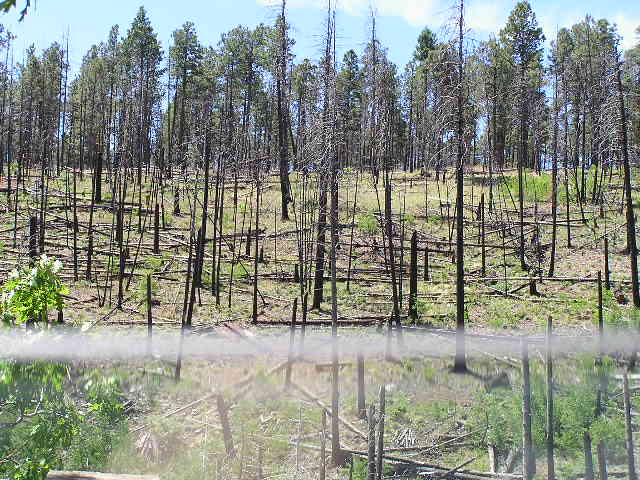

 We will post the Bandelier area later. Today, DW is at the laundry, we have a DR appointment at the Santa Fe VA clinic and we are going to get some fresh veggies and fruit at the store. The Walmart here is not a supercenter. We are atleast 41 miles to a store one way. So we plan a store stop on our day trips to take advantage of the gas. And if we can, movie time at the theatre.
Edit 3:25 pm- we are back from the DR and the store. I have a staphy infection on the leg incession. The DR gave me a Rx for antibotics. We got our veggies and fruits at Smiths by the VA clinic.
We try to post daily even if we have no photos for you to see. We have been to everything close by and we will be moving north of here to another COE park probably tuesday. We are paid, $6.00/day, for 14 days here. Pretty darn cheap for water and elec and a dump station. we went over our budget for last month of @1200.00 by about $300.00. Most of that was for gas to get here from Pecos, TX. We have a full tank in the RV and use the car for our trips. Look back at the mileage this trip took. We will be doing more of the same when we move. We are planning on seeing Red River, Taos, Angel Fire and surrounding area the 14 days we are there. From there we are planing on going toward Aztec, NM. We have not made any further plans after that.
This will give you an idea of where we are going in the weeks ahead. As always, our location is shown by our GPS location on "Where WE are now" link. And do look at all the photos in our photo link. We have nearly 70 total photos posted.
Its 66, cloudy with possible showers.
For May:
RV mileage- 673
Car mileage- 1106
Wednesday, May 31, 2006
The Tuesday Jemez Mountain Tour Day Trip, Part 2
 The dam is quite interesting in the way it is continuing to be formed.
 This is a closeup of the water coming thru the dam. The dam is formed by hot springs and the mineral deposits brought up from below. Over time a dam was built that is holding back the Jemez River. Its not a large dam but it is natural and worth the trip.
 Here she is getting into the car after we took the photos below the dam. That is the dam in the background. We are closer than it appears. The car has just over 150,200 miles and running fine. Its worth about $250.00 a month for every month we have it. It has a few front end dings but the paint is good and it has been kept repaired so the car is paying us back. Anyway, its worth $800.00 max. We kept it over the 1996 Lincoln Mark VIII we had. A simple matter of cost of upkeep.
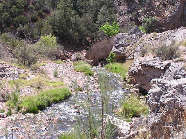 This is the other photo Shirley took of the water above the dam.
 We went on down the road and came to the Soda Dam. The above is the water upstream that is being blocked by the dam.
 We continued our drive on NM4 and came to the battleship rock by the road. It looks like a battleship bow to me.
 The bow as it appears from the road. We have driven higher in the mountains and now we have pine trees vs mainly cedar trees. The view of the mountains with their different mineral colors and formations is worth the trip. There is more to come on down the road. See the photo link for all the pictures we have taken on this day trip.
Tuesday, May 30, 2006
The Tuesday Jemez Mountain Tour Day Trip, Part 1
We left this morning about 7:45 am for our day trip to the Jemez Mountains and Bandelier National Monument. This trip is long and we allowed all day. And it took till 3:30 pm to return. We drove some 231 miles with a 16 mile double back from White Rock back to Bandelier.
 We left the lake and went to I25 then south to US550 in Bernalillo which is north of Albuquerque. From US550 we took NM485 to see the Gilman Tunnels. US550 is a nice wide two lane road. The turn off to NM485 is quick and with a short warning. The road is a narrow two lane with no shoulder. Immediately after the exit, there is a one lane bridge. This is not a trip for any RV.
 The road is not high on the maintance list, so do follow the slow speed limits. As you get near the tunnels, the road becomes a one lane paved with turnouts. There is probably more no passing than passing to the tunnels. The tunnels were made back in the 20's for the logging trucks to use from the area north of the tunnels along the Guadalupe River.
 There is lots of room inside the two tunnels. Yes there are two about 100 yards apart. They were blasted out of rock and are impressive. There is a stream along side the road up here in the canyon. The canyon walls become shear and high as you go up the road. As I told DW, the walls are closing in.
 Here is the stream below at one of the turn outs. Dont get to close to the edge as its a cliff to the water.
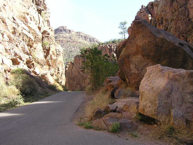
 A look from inside the tunnel to the outside. This gives you an idea of the size of the tunnel walls and ceiling.
 Viewing one tunnel from another. Quite a feat then and now to blast a hole thru rock.
There is more to show as we took about 70 photos of the total trip. All of them are posted on our picture link. And we did get another panarama photo of the trip. If we can get the movie software to "see" the camera, we will be able to post "movies" of our trip which will be much more enjoyable and comprehensive than photos some time.
 We left the lake and went to I25 then south to US550 in Bernalillo which is north of Albuquerque. From US550 we took NM485 to see the Gilman Tunnels. US550 is a nice wide two lane road. The turn off to NM485 is quick and with a short warning. The road is a narrow two lane with no shoulder. Immediately after the exit, there is a one lane bridge. This is not a trip for any RV.
 The road is not high on the maintance list, so do follow the slow speed limits. As you get near the tunnels, the road becomes a one lane paved with turnouts. There is probably more no passing than passing to the tunnels. The tunnels were made back in the 20's for the logging trucks to use from the area north of the tunnels along the Guadalupe River.
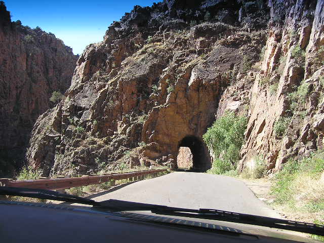 There is lots of room inside the two tunnels. Yes there are two about 100 yards apart. They were blasted out of rock and are impressive. There is a stream along side the road up here in the canyon. The canyon walls become shear and high as you go up the road. As I told DW, the walls are closing in.
 Here is the stream below at one of the turn outs. Dont get to close to the edge as its a cliff to the water.
 A look from inside the tunnel to the outside. This gives you an idea of the size of the tunnel walls and ceiling.
 Viewing one tunnel from another. Quite a feat then and now to blast a hole thru rock.
There is more to show as we took about 70 photos of the total trip. All of them are posted on our picture link. And we did get another panarama photo of the trip. If we can get the movie software to "see" the camera, we will be able to post "movies" of our trip which will be much more enjoyable and comprehensive than photos some time.
Monday, May 29, 2006
Its Monday and Its Memoral Day

At 1:30 pm, its a cool 72 and still calm winds. We went walking and most of the park is empty. There are a few spots still filled.
Across the lake is the other park. Its a 19 mile drive from the gas station and laundry. Here we have DW out looking at another camp site. Some of them have the table below the parking space. And some of them have the table above the parking space.
Tomorrow is sightseeing day.

It was a cool 46 overnight and a warmer 52 now. I woke up to calm winds. After the last two days, calm winds is nice. We are 24 miles from Santa Fe, 17 miles from I25 and our weatherbug brings us their weather. It is suppose to be 10-15 mph winds today. More as the day progress.
![]()